

We start the New Year with big news! We just released the 18th version of our Field Service Management & route optimization tool, GeoTask. We constantly improve our solution so it answers dispatchers’ and field technicians’ needs. The new version is based on our clients’ suggestions and the changing industry needs. Let’s see what’s new in GeoTask 18.0!
New, more intuitive and clear User Interface (UI) for improved task management
In the 18.0 version, we improved the map clarity and aspects related to creating and completing tasks. We also enhanced schedule configuration for more efficient planning and managing fieldwork. We present the main changes in GeoTask’s UI:
New task editor
We created a new interface for the task editor, now consisting of a single tab.
- Using the “Customer” and “Address” buttons, the user can choose whether the task is created for a customer existing in the Customer module or for any address. It makes it faster to create tasks for clients saved in the database. On the other hand, it provides an option for creating tasks related to addresses that aren’t assigned to any customers.
- We added hints for the following fields: Customer name, Location, Contact person, Phone number, and E-mail. Hints appear when the user starts typing in any of these fields. After selecting a value suggested by the hint, the rest of the fields automatically fill out with data from the Customer module. It facilitates creating tasks and helps avoid mistakes and delays resulting from incorrect customer data.

More intuitive new task editor
Existing task editor
This editor was designed so that users can faster reach crucial task information.
- Information about the Customer and the Order number are now displayed in the top bar of the editor.
- Task information such as Planned completion date, Actual date, Team, Team composition, and Technician’s comments are now displayed as read-only in the Execution details section.
We made it easier for technicians to add information about tasks:
- We added the Notes section opened by clicking the Magnifying Glass icon. In this section, a field technician writes down data collected when completing the task. Through the Note editor, dispatchers can view collected information and attached photos and add more info if it’s needed.
- We added the Attachments section. To prevent users from accidentally deleting attachments, a warning message will be displayed when they click on the trash icon.
Gantt chart configuration
In the new version, we refined the Gantt chart configuration in the Dashboard menu. All configuration options are now placed above the Gantt schedule, as pictured below. This way, finding them is easier and faster.

Schedule with the configuration panel at the top of the screen
- We added different view options: detailed, compact, and convenient, depending on the needed range of information.

Detailed view on the Gantt chart
- We also introduced changes in the task tooltip on the Gantt chart. If a task is associated with a location, the name of that location will appear in the task tooltip.
- We changed the column configuration on the chart. The detailed view presents all users included in the Team.
- We changed the icon of high-priority tasks to an exclamation mark in a red circle.
Saving component sizes in the Dashboard
Users can now freely change sizes and configure the visibility of components in the Dashboard (Task lists, Maps, and Gantt chart). Changes are saved for each user, so they don’t have to adjust their preferences each time they log in.

Adjusting the colors of elements to match the application design
For improved clarity and user experience, we changed the colors of the following elements:
- buttons;
- lists;
- lists with checkboxes;
- current timeline;
- map icons;
- captions of map icons.

Map improvements
We introduced changes to increase map clarity and help users manage tasks.
Task icons on the map
Map improvements in the new GeoTask version include task icons:
- The task icon shape can be adjusted to the type of task.
- The task icon color depends on the current task status.
- High-priority tasks are marked with a red dot next to their icon.
- We modified the base map to highlight key elements and increase transparency.
- We adjusted the task label color to match the blue application design.
New, clearer map
Cluster icons on the map
We also changed the cluster icon. Its size depends on the number of tasks within the cluster. A larger icon means more tasks. The administrator can modify cluster settings, too.

Cluster size depends on the number of tasks
Customer and Location Module – easier task management and task progress tracking
One of the brand-new dispatcher functionalities in GeoTask 18 is the Customer and Location Module. It contains contact information about regular clients and their locations. The module allows dispatchers to manage customer data easily.
Customers and Locations can be loaded into GeoTask from a CSV file one by one or in bulk. Customers can have one or many locations.
Tasks can be created one by one or in bulk for chosen Locations of each Customer. For this purpose, dispatchers can use saved Customer or Location names and not their addresses.
The Customer Module provides an overview of ongoing and completed tasks for chosen Customers or Locations.

Customer Module with information about regular clients
Each Customer and Location has its Ongoing task list and Task history.

Customer Module – Ongoing and completed task lists
Notification Module – improved task status reporting
We created the Notification Module for creating and managing client e-mail and SMS notifications. In GeoTask 18, we changed options for configuring notifications and introduced improvements for SMS management.
Configuring notifications
These are our changes in the Configuration editor:
- We added event types for sending messages: Appointment creation, Appointment date change, Appointment technician change, Task creation, and Task cancellation.

New options for configuring notifications in GeoTask 18
- We added an option for choosing the message type: SMS, e-mail, or both. SMS and e-mail titles and templates can be configured separately.
- We also changed the method for choosing the date for sending notifications: After appointment creation, the Day before the appointment, and During the appointment day.
This helps automate the process of notifying clients and ensures they are always up-to-date about their task status. This results in increased customer satisfaction.
Setting the number of SMS notifications
Now, the user can set the maximum number of SMS notifications sent each month. This helps to control the number and cost of sent SMS notifications.

Setting the number of SMS notifications per month helps control costs
Setting time for sending SMS notifications
The system administrator can set the time for sending SMS notifications.

GeoTask allows the administrator to set the time for sending SMS notifications
The SMS report
The application counts the number of SMS messages sent each month and presents it in the SMS Report tab. Reports are generated for each year. They give insights that make it easier to plan and control costs.

The report of SMS notifications sent each month
Customized additional fields for adjusting the range of task information to your needs
In the Details section of the Task editor, you can now configure up to 20 additional fields by their name, type, and dictionary.

Optional field about task details with additional information
Mobile app improvements – better task management in the field
More options for creating tasks
We changed the window for adding New Tasks in the mobile app. When creating tasks, users can now choose Customer locations. They can also pick “Any address” to make a task not associated with any customer location.
Moreover, after choosing a Customer location or Any address, users can edit the following fields: Area, Contact person, Phone number, and e-mail.
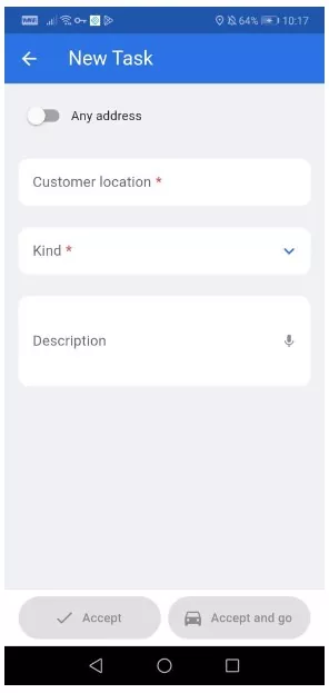
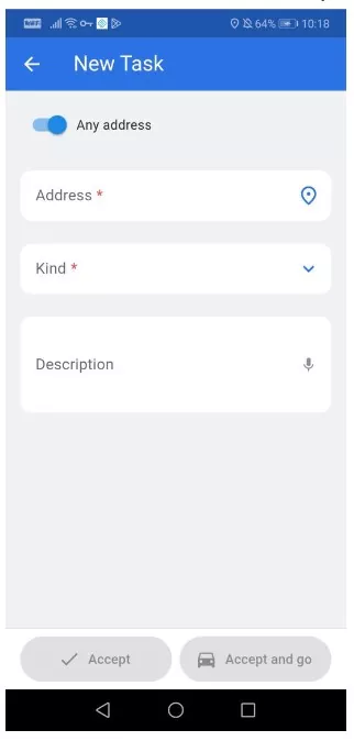
More options for creating tasks in the mobile app
Scheduling the next appointment in the mobile app
A technician out in the field (e.g., visiting a customer’s location) can schedule the next appointment right away using the mobile app. There is no need to contact customer service, limiting the number of required calls. Customers can easily pick the best time for the next technician visit.
What else is in our plans?
In this article, we described the main changes in the 18.0 version of GeoTask. It’s not the end though, as we already plan our work on the next edition! In GeoTask 19.0, we plan on adding the Storage Module for tracking the lifecycle of equipment or goods in storage.
Do you have questions or suggestions regarding GeoTask?
If you have any questions about our app or suggestions regarding further improvements, let us know!
If you’re not using GeoTask just yet, request a live demo and see how GeoTask can help you improve your field service management.